|
The
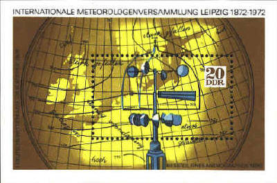
miniature sheet from the German Democratic Republic is based on a
manuscript map drawn by Waldimer Köppen in 1876 which has lines
showing wind speed.
"The
design of the Meteorological Readings postage stamp incorporates an
authenticated section of a recent surface weather map prepared by the
Meteorological Branch of the Canadian Department of Transport."
Canada Post Office
Department
Postage Stamp Press Release, 1968

The
contours on the map indicate barometric pressure. H and T indicate
"Highs" and "Lows." The symbols in the weather map below indicate the
nature of the weather in the area. The blue points indicate cold
fronts; red half circles, warm fronts; triangles, showers; circles
with a line, wind coming from the direction of the line to the circle;
one bar at the top of the line,8-12 knot wind; the amount of black in
the small circle, the amount of cloud cover.


 |
