|
Discobolus
The stamp was issued in
1932 to mark the Olympic Summer Games that year. The figure of the
discus thrower is based on a marble copy of the bronze sculpture
Discobolus by Myron (about 450
B.C.) in the British
Museum in London. The image of North America on the globe is obscured
by the figure.

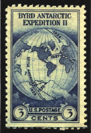
Little America
The Little
America stamp was issued in 1933 to recognize the expedition of
Admiral Byrd to the Antarctic. The stamp was never sold at any post
office, but only used on letters mailed through the Little America
post office. The map shows the whole world on one side of a globe in
the van der Grinten projection. For further information on the
projection see Projections. The map shows his routes in the
Arctic in 1925 and 1927, and in Antarctica 1929 and 1933.In 1934 a
miniature sheet of six stamps was issued to recognize the National
Philatelic Exhibition in New York City.
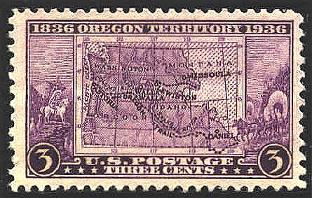
Oregon Territory
Congress created
the Oregon Territory on August 14, 1848. It covered an area
encompassing present-day Oregon, Idaho, Washington, and western
Montana. To commemorate the 100th anniversary of the Oregon Trail this
stamp showing a map of the Oregon Territory was issued. The dotted
line indicates the route of the Oregon Trail. Five places are marked
on the map, one in each State. They are the places selected to have
first-day sales. In 1993 a stamp was
issued to mark the 150th anniversary of the Trail.
Northwest Ordinance
The
Northwest Ordinance was passed by the Articles of Confederation
Congress passed the Ordinance of 1787, which provided for the creation
of up to five states in the northwest portion of the Ohio
Valley. The area, known as The Northwest Territory, was east of
the Mississippi, and between the Ohio River and the Great Lakes. The
present states of Ohio, Indiana, Illinois, Michigan and Wisconsin were
created from the Territory. In 1937 the 150th anniversary of the
Ordinance was commemorated with this stamp. The design displays The
Northwestern Territory and the Territory Southwest of the Ohio River
in Foster's Forty Maps Illustrating United States History,
Topeka, 1905.

 |