|
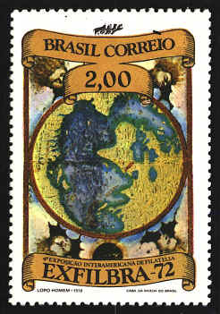
Lopo
Homem (d. 1565) was a 16th century Portuguese cartographer. In 1524 he
served on the commission established by the Portuguese and Spanish
crown to set the limits of their respective spheres of navigation. He
was the father of Diogo Homem who was also a cartographer.
Homem
was appointed mestre de cartas de marear, or Master of
Navigation Charts, by King Manuel I of Portugal. One of his tasks was
the creation of a manuscript atlas as a gift from Manuel I to Francis
I of France. The Brazilian stamp represents the introductory map in
the so-called “Miller Atlas” of 1519 in the Bibliothèque Nationale in
Paris. The map, drawn by Homem, is fairly accurate in those areas
explored by the Portuguese, but it is full of inaccuracies and
exaggerations elsewhere. On the stamp the map is printed with Brazil
on the top so the wind deities pictured on the original could be
included in the design.
Homem
was concerned about the quality of the individual maps, so he asked
Pedro Reinel for help. Reinel is the first Portuguese cartographer
whose name is recorded. His son, Jorge, was also a cartographer, and
both were involved in the production of the atlas.
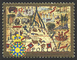
The
stamp below shows the mouth of the Ganges River in India on a chart by
Pedro Reinel in the 1519 atlas.
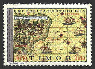
The
stamps below shows a portion of Brazil on a map entitled Tabula hec
Regionis magni brasilis... from the Atlas. The map identifies many
locations on the coast and the interior is filled with pictures
representing South American life. It shows the coast and
interior of Brazil. Figures of natives, birds, and animals fill the
interior, while the names of various locations are inscribed around
the coast of Brazil. The red line is the Tropic of Cancer.
 l l


|