|
Gerard de Jode was
born in Nijmegen in 1509, and died in Antwerp in 1591. In 1547 he was
admitted to the Guild of St. Luke, and became a print seller. In 1550
he was licensed as a printer. He printed Jacopo Gastaldi's map of the
world in 1555, Jacob van Deventer's map of Brabant in 1558, maps by
Bartholomeus Musinus, Fernando Alvares Seco, and Abraham Ortelius'
eight sheet map of the world in 1564. In 1578 he published his
Speculum Orbis Terrarum. Plate IX was the map which is reproduced
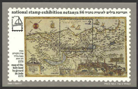
on the souvenir sheet honoring NETANYA ‘86 National Stamp Exhibition.
The map was created by Tilleman Stella, a German
mathematician and mapmaker, in 1557. It covered the territory of
Palestine in great detail, identifying 291 places by name, on a map
that measured 12 by 20 inches. The map also included three insets,
Jerusalem, Bethlehem, and a third unidentified picture. The map was
engraved by the brothers Jan and Lucas van Doeticum. This map was to
become “a prototype for the modern cartography of the Holy Land”
(Kenneth Nebenzahl, Maps of the Holy Land: Images of Terra Sancta
Through Two Millenia, New York: 1986, p. 85)
The map is oriented to the northwest. The Dead Sea is
misshapen. The Jordan River is one of several rivers identified. The
final stages of the Exodus from Egypt is marked by double dotted lines
just to the left of Jerusalem. The resort of Netanya, the location of
the exhibition is located on the coast about half-way between to two
vertical boundaries of the stamp on the sheet. It was not founded
until 1929.


 |