|
Bartolomeo Columbus
sketched three maps in the margin of a letter written by his brother,
Christopher, in Jamaica on July 7, 1503 to the Spanish sovereigns,
pleading for the restoration of his honor and fortune. The maps cover
the territory from "Asia," that is, the American continent on the west
to China on the east, and generally between the two Tropics. Some
believe that the map attributed to Bartolomeo Columbus was actually
drawn by Alessandro Zorzi.
The map portrayed on the left stamp covers the coasts
of Central America, Columbia and Venezuela. "Asia" clearly indicates
that even at this time he still believed he had reached the Orient. On
this map "Serica" means China, "Serici Montes means Chinese mountains,
and "beragua" means Veragua, Panama. Cattigara is a port in India, and
the interrupted coastline indicates an isthmus leading to the "Sinus
Magnus."
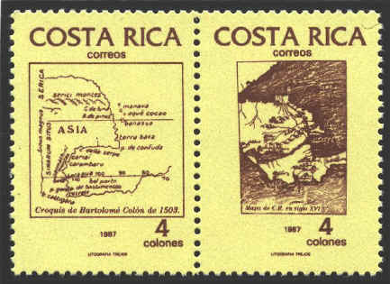
The map
on the stamp on the right is identified as a map of "C. R. [Costa
Rica] from the sixteenth century," with no indication of who created
it.


 |