To determine the exact size and shape of the
earth George Wilhelm Struve (1793-1864) determined to create an arc
based on triangulation. 258 triangles and 60 subsidiary station points
were measured. Today the arc passes through 10 countries (Norway,
Sweden, Finland, Russia, Estonia, Latvia, Lithuania, Belarus, Moldova
and Ukraine).
Beginning in 1994 these countries have sought to
recover and verify the monuments, and in 2005 UNESCO approved
inclusion of the Struve Geodetic Arc in the World Heritage List.
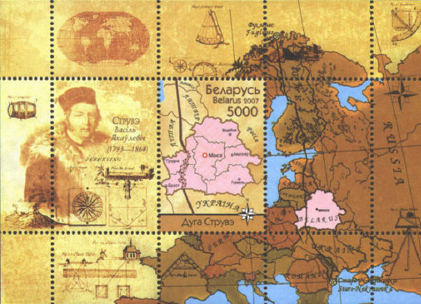
In 2007 Belarus issued a sheet to commemorate the
Struve Arc. It features an old map, with modern country boundaries
superimposed, a portrait of Friedrich Georg Wilhelm von Struve based
on a lithograph by H. Mitreuter after a portrait by C. A. Jensen,
1844, and 10 or more illustrations of survey instruments, an oval map
of the world, two 4 point compass roses, and, on the single stamp,
a modern map of Belarus with the inscription "Struve Arc" in Cyrillic
at the bottom. In addition the route of the Struve Arc is
traced on both the large map and the stamp.


|
