|

Vassili Mikhailovich Golovnin (1776-1831) explored and mapped the
Kurile Islands northeast of Hokkaido, Japan to Kamchatka. While
exploring the Kunashir Island, Golovnin was taken prisoner for two
years by the Japanese. The map on the stamps features a map of the
expedition route in 1811, a picture of the sloop Diana, and a picture
of the Petropavlovskiy port in 1811. Golovnin rose to the rank of Vice
Admiral, and was a Corresponding Member of the Russian Academy.

Adam Johan Ritter von
Krusenstern (1770-1846) was the author of The Southern Seas Atlas. The
map featured on the stamp with the planned route of the first Russian
circumnavigation of the globe from east to west, 1803-1806. The stamp
also has pictures of the ships Neva and Hope, a picture of the Main
Admiralty in St. Petersburg (before 1806), and a pennant of the sort
used from 1732 to 1917.
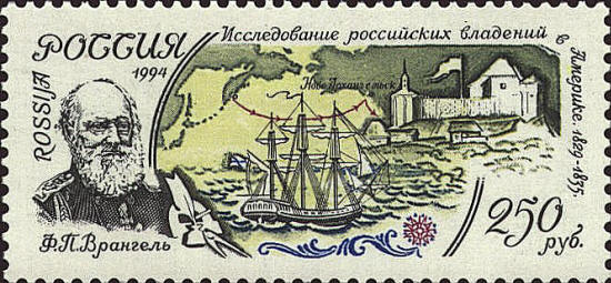
Ferdinand Petrovich Wrangel
(1796-1870) described the Siberian coast from the Indigirka River to
Kolyuchinskaya Bay. He located the island later named for him. The map
on the stamp is of Kamchatka and Alaska, the route of his expedition
in North America, and pictures of the ships Krotkiy, the ship Wrangel
commanded on a world cruise in 1825-1827, and a picture of
Novo-Archangelsk where he held the post of chief administrator of
Russian possessions in North America in 1829-1835.

Fedor Petrovich Litke
(Lütke) led an expedition of “New Land” islands in 1821-1824. He was
also president (1864-1882) of the St. Petersburg Academy of Science.
The map on the stamp shows a plan of the 1821 expedition and a view of
the “New Land” in the background.
 |
