|
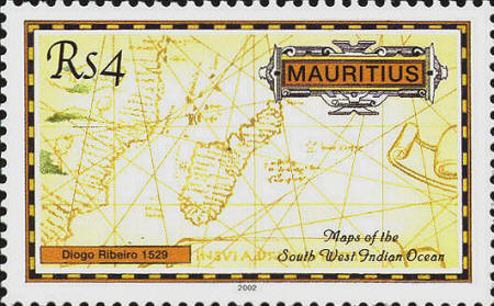
Diego Ribero
was a Portuguese who had sailed to India with Vasco Da Gama and
Alfonso de Albuquerque. He entered the service of Spain and assumed
responsibility for maintaining the padron real—the master chart
which incorporated geographical reports from Spanish ships when they
returned to their home ports. It is the first map to show the true
size of the Pacific Ocean. It is also the first sea-chart to embody
cosmographic information: a calendar, a quadrant, an astrolabe and a
declination scale, with texts explaining their use. The map is in the
Biblioteca Apostolica in the Vatican. The map shows the east coast of
North and South America, the Atlantic Ocean, Europe and Africa and
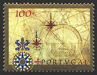
Asia to the east of India. The compass roses and astrolabe
pictured on the stamp are from the lower right hand corner of the map.
The
full title of this world map is Carta Universal En que se contiene
todo lo que del mondo Se ha descubierto fasta agara: Hizola Diego
Ribero Cosmographo de Su Magestad: Año 1529. La qual Se devide en
dos partes conforme a la capitulcio que hizieron los catholicos Reyes
de españa, y El Rey don Juan de portugal e la Villa de Tordesillas:
Año 1494 [General chart containing the whole of the world
that has hitherto been discovered; complied by Diego Ribero,
cosmographer to His Majesty, in the year 1529, which is divided into
two parts according to the agreement made by the Catholic Majesties of
Spain and King John of Portugal at Tordesillas, A.D. 1494].


 |