|
Moreila ~ 1767
In 1987
Mexico issued this stamp in recognition of the 13th International
Conference of Cartography. The subject is officially described as "A
photographic composition of an antique plan provided by the General
Archives of the Nation," without any more specific description.
The map is a sixteenth century manuscript map of
Moreila, one of the oldest colonial towns in Mexico.

In 1991 Mexico issued a
stamp to celebrate the 450 anniversary of the founding of Moreila.

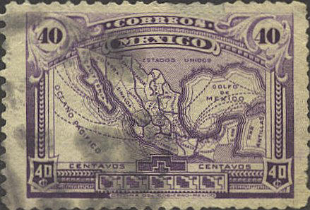
Mexico 1915
The map shows railroads
within Mexico and shipping routes to the rest of the world. The
Caribbean Sea is identified as "Mar Antillas." The names of many of
the states are abbreviated, and the state of Colima is not named at
all, The boundaries of the northern part of the state of Quintana Roo
are cut off by the territory of Yucatan, and the boundaries of
Quintana Roo encroach on the territory of British Honduras, later
Belize. (See also in the Errors section.)

|
