|

The image on the
Belgian stamp of 1962 is based on an engraving in 1574 by Frans
Hogenberg, who also engraved some of Mercator's maps. The engraving of
Mercator first appeared in his 1584 edition of Ptolemy's Geografia.
It also appeared in the 1595 editon of Mercator's Atlas,
published after Mercator's death by his son, Rumold.
The view of the earth on the globe included "America"
under Mercator's left hand, with the North Pole under the compass in
his right hand.
Gerard
Mercator (Kremer) was born in Rupelmonde in East Flanders in 1512. He
studied under Gemma Frisius at Louvain. He began producing maps in
1537, and issued his famous Mercator projection in 1569. In this
projection a straight line between any two points would describe the
loxodrom between them. His atlas was published in three parts in 1585,
1590, and 1595, a year after his death. Jodocus Hondius bought
Mercator’s plates and issued several editions of the atlas enlarged
with his own.
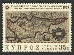
On Mercator’s map of Cyprus the eastern part of the island is shown as shorter and broader than it
is; also the direction of the island is shown as directly east-west,
which is not the case. The map was published in 1590. The map of
Africa is dated 1595. The one of South America is from a 1606 atlas.

The map Mercator was
published in 1606 in Hondius' "Mercator Atlas." Mercator's map is
oriented to the south. For the stamp the map has been rotated 180°, so
that the top is to the north.

 |