|
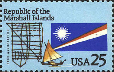
Stick Chart
Stick-charts were used to teach and record the swells of the sea. The
charts were hardly maps in a western sense: the cowrie shells did
signify islands, but they could often be taken to be any island.
Distances were quite arbitrary and charts were meaningless without the
guidance of their maker. The charts were not taken to sea, but
memorized.
There are two basic kinds : the mattang
and the rebbelib, the first for instruction only in
swell-patterns, the second showing the place of islands in the group
or one of its chains. A third type, the medo, was more local,
placing a few atolls only. Some believe these last two to be of recent
introduction, influenced by western chart-making.
The chart on the stamp is of the rebbelib type
and presumably shows the Marshall Islands.
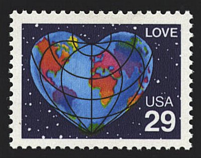
Love
This
projection which is thought to have been perfected by Apianus, was not
devised because of its artistic possibilities; it was based upon a
carefully conceived formula designed to maintain distances. It was
described by Johannes Werner in Nova translatio primi libri
geographiae C. Ptolemaei, Nuremberg, 1514, and first published
bound with the edition of Solinus' Polyhistor given at Vienna
by Johann Kamers [Camertius] in 1520. The projection is equal-area and
shows distances correctly to scale only from the center.
Iceland, Madagascar and Sri Lanka are missing
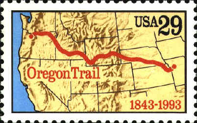
The Oregon Trail ~ 1843
The
Oregon Trail began near Independence, Missouri and ended nearly 2000
miles west at the Columbia River near the Pacific Coast. The stamp was
issued to mark the one hundred fiftieth anniversary of the Oregon
Trail. The original design showed the east-west border of Washington
following the course of the Snake River. The design was corrected so
that the border follows the 46th parallel to the Idaho border in the
stamp that was issued in 1993. A stamp issued in 1936 (SCN 783)
also shows a map with the Oregon Trail.
 |