|
The Great Trigonometrical Survey in India
began in 1802 when William Lambton laid the baseline from St. Thomas
Mount 12 km to a hillock near Pallavaram to determine the length of a
diegree of latitude along a longitude in the middle of the
sub-continent. Lambton and George Everest spent the next 50 years
creating a geometric web of trianulations, 2400 km long, across the
length of the sub-continent, the "Great Indian Arc of the Meridian."
The purpose was to form the basis for an accurate survey of India, and
in addition to determine by actual measurement the magnitude and
figure of the earth. The Survey is commemorated by the stylized map of
India on the middle stamp.
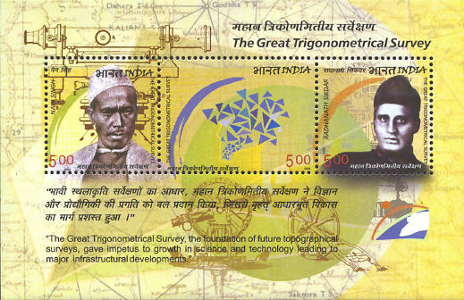
Nain Singh (1826-82) and
Radhanath Sikdar (1813-1870) are also pictured on the souvenir sheet.
Singh explored the Himalayas, mapped the trade route to Tibet, mapped
a large part of the Tsangpo River in Tibet, and determined the
altitude and coordinates of Lhasa.
Sikdar (1813-1870) joined the Survey in 1840. He
calculated the height of Peak XV (later renamed Mt. Everest), and
determined that it was the highest mountain in the world.


|
