|
Even after Captain James
Cook (1728-1779) sailed through the Endeavor Strait between Cape York,
the northernmost point of the Australian mainland, and Thursday Island
to the north in 1770 (south of the Torres Strait), he didn’t claim to have proved that New Guinea
was an island separate from what was later known as Australia. He
cautiously wrote that “as I believe it was known before, but not
publicly, I claim no other merit than the clearing up of a doubtful
point.”
Pedro Fernandez de Quirós (ca. 1565-1615) had claimed
in 1606 that New Guinea and Australia were one continent. But a
document written by Jean Luis Arias, a lawyer in Chili between 1614
and 1621 refers to New Guinea as “a Country encompassed with water"
which shows that Spain knew better.
Willem Janszoon (ca. 1570-aft. 1629) sailed through
what later was known as the Torres Strait in the Duyfken (“Little
Dove") between the 18th November, 1605, and June 1606, and later in
1606 Luis Váez de Torres (d. 1613?) also sailed through the strait.
The explorer and cartographer, Manuoel Godhino de Erédia (1563-1623)
prepared a map to show the Torres' course in 1606. His map is shown on a stamp issued by Papua New
Guinea in 1970.

Luis Váez de Torres was
second in command of Quirós’ expedition. He coasted southern New Guinea (called
Magna Margarita), sighting Long Reef off Cape York (called Volcan
Quemado). He then crossed the Strait that bears his name between the
1st and 9th October 1606. For many years it was assumed that Torres took a route
along the New Guinea coast, but in 1980 the Queensland historian and
seaman Brett Hilder demonstrated that it was much more likely that
Torres took a southerly route, from which he would certainly have seen
Cape York, the northernmost extremity of Australia.
In 1762 a transcription of the report by Luis
Váez de Torres was sent to Alexander Dalrymple (1737-1808) by Juan Bautista Muñoz. Dalrymple had it
translated into English and it was printed by Rear–Admiral James
Burney in A Chronological History of Discoveries in the Pacific
(1806). According to the London Gazette August 19, 1768, “It is no
secret that the noted hydrographer, Alexander Dalrymple, who was
originally the Royal Society's choice for Commander of the Endeavour,
before the Lords of the Admiralty insisted on Lt Cook, has given to
Mr. Joseph Banks a secret document he discovered while on expedition
in Madras. This is believed to contain the statement of Capt. Luis Váez
de Torres that he sailed between two great land masses in
the far South more than one Century and a half since.”
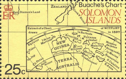
In 1981 the Solomon Islands issued a mini-sheet of four
stamps which included an extract of a chart by the Flemish
cartographer Cornelius Wytfliet (fl.
1597), Chica sive Patagonia et Australis Terra, which shows that the
separation of New Guinea and Australia was already known more than ten
years before the voyages of Janszoon, Quirós, and de Torres. He wrote in his
Descriptionis Ptolemaicæ augmentum, sive Occidentis notitia brevi
commentaro illustrata, studio et opera Cornelli Wytfliet Lovaniensis, 1597, "The Australis Terra is the most
southern of all lands. It is separated from New Guinea by a narrow
strait. Its shores are hitherto but little known, since, after one
voyage and another, that route has been deserted, and seldom is the
country visited, unless when sailors are driven there by storms. The
Australis Terra begins at two or three degrees from the equator, and
is maintained by some to be of so great an extent that, if it were
thoroughly explored, it would be regarded as a fifth part of the
world."
Aldama Ayala, Compendio Geografico Estadistico de Portugal y
sus posesiones ultramarines, 1855, claimed that Australia was
discovered by Fernão Magalhaens in 1520. He based his claim on a map
by Fernão Vas Dourado in 1570. It would have been claims like this
that formed the basis for Wytfliet's description. More recently
Ayala's claim has proved to be a mistake of the northern coast of New
Guinea for part of the coast of New Holland,
R.H. Major, Early Voyages to Terra Australis, now called Australia.
London, 1859, pp. xxi-xxiii.
Thanks to Michael YAO for his observations and suggestions.
The documents mentioned above by Jean
Luis Arias and Luis Váes de Torres can be found at the following
location:
http://gutenberg.net.au/ebooks06/0600361.txt.
  |
