|
Pedro de Medina was the Royal Cosmographer of Spain in the 16th
century. He published the first manual for compass navigation, Arte
de Navagar in 1545, and his Suma de Cosmographia in 1550.
The map on the souvenir sheet issued in 2006 by Spain is from the
Suma. It has been described as "quite detailed regarding
the Atlantic coast of America, showing the mouths of the Mississippi,
called Rio
del Espiritu Santo, the St. Lawrence and the Amazon, as well as
Labrador, Florida, Cuba, Panama and Brazil.
The map has five "circles," Circulo Artico,
Tropico de Cancer, Linea Equinocial, Tropico de Capricorn,
and Circulo Antartico. There are two vertical lines, the line
of the Treaty of Tordesillas (1494), 1550 miles west of the Cape Verde
Islands, near 39°53'W, and a line that appears to be marked with
latitudes. South America is designated as Peru, and the first 2
letters of Africa are visible on that continent. Other details and not
clear.
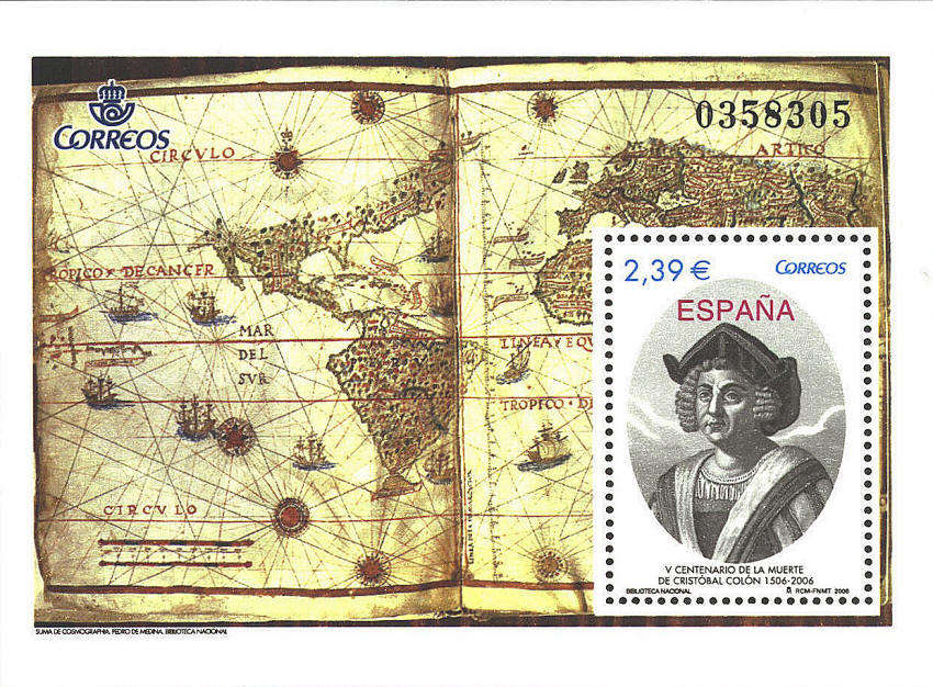
The souvenir sheet was issued to commemorate
the 5th centenary of the death of Columbus in 1506. No likeness of
Columbus was made during his lifetime. The portrait was made by
Ambroise Tardieu (1788-1841) and published by Theodore de Bry in Histoire de
l'Amerique, 1565. The map is preserved in the Biblioteca
National in Madrid, and the portrait in the Galleria de Palazzo
Rosso in Genoa.
A further note: Pedro de Medina was commemorated with
the naming of a mountain in Antarctica in his honor.
 
 |
