|
In 1563 the area
of the Viceroyalty of Peru known today as Ecuador was made an
Audienceia, a judicial administrative district, with its
headquarters in Quito.
The map is based on a map drawn by Don
Francisco Requena in 1779, with the exceedingly long name: Mapa que
comprende todo el estrito de la Audiencia de Quito en que se
manifiesta con la maior individualidad Los Pueblos y Naciones barbara
que hay por el Rio Maranon y demas que en el entran, para acompanor A
La Descripcion del nuevo Obispado que se proyecta en Maynas.
Construido de Orden del Senor D. Josef Garcia de Leon y Pizarro
Presidente Regente Commandante y Visiador Gral de la misma Audiencia,
Por Don Francisco Requena, Yngeniero Ordinario Governador de Maynas y
primer Comisario de Limites el Anno de 1779.
Requena recognized the contributions made by various
surveyors and mathematicians, including Charles M. de la Condamine and
his associates. They were in the Audiencia in 1736 to determine the
length of a degree of latitude to so settle the question of the
shape of the earth, flattened or budging at the poles. The engineer
Louis Godin, who was a part of the la Condamine expedition assisted in
the rebuilding of Callao after the earthquake of 1746.


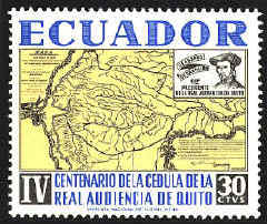
The
stamps were issued in 1964 in observance of the fourth centenary of
the establishment of the Audiencia in Quito.


 |