In 1606 Quiros discovered Tierra Austral del
Espiritu Santo. Captain James Cook visited the island in July and
August of 1774, and renamed the islands the New Hebrides after the
islands north-west of Scotland. Independence was achieved in 1980, and
with it a new name, Vanuatu, meaning “Rising Land.”
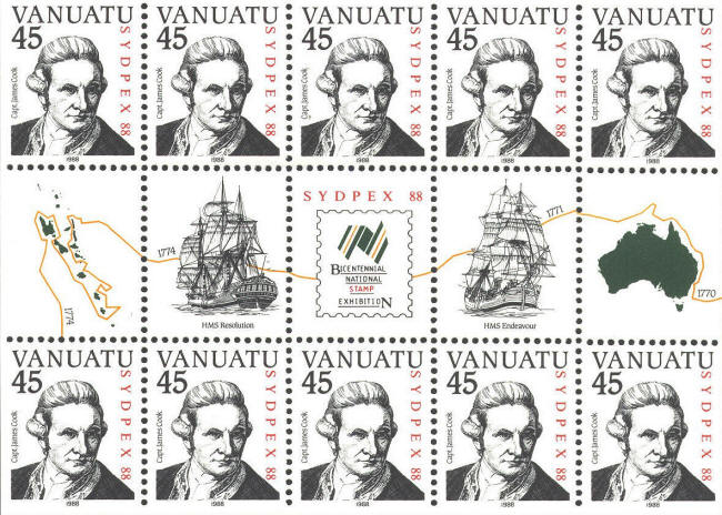
In 1988 Vanuatu issued a souvenir sheet featuring ten
stamps with a portrait of Captain Cook based on the portrait painted
in 1775 by Nathaniel Dance, plus 5 labels with pictures of Cook’s two
ships, HMS Endeavor commanded by Cook on his first voyage, and HMS
Resolution in which Cook made his second and third voyages, and a map
of Australia and Vanuatu.
The map incorrectly implies that Vanuatu is west of
Australia about 12,500 miles (20,000 km), while, in fact, lies east of
Australia about 2,300 miles (1,400 km). The orange line showing a
route from Australia to Vanuatu with indications of years, 1770, 1771,
1774, also implies the course of Cook’s explorations leading up to
arriving at Vanuatu. However, 1770-72 is the time of the first voyage,
and 1774 is the year Cook actually visited Vanuatu. So, the both the
time and the course are in error. The two ships are placed on the
course line with the years in proper relation to each other, the
Endeavor in 1771, and the Resolution in 1774.
Mark Honig called my attention to this sheet.
Reportedly, only 7000 copies of the sheet were issued.
http://www.btinternet.com/~musyat/cook/pac_fr.html.


 |
