|
Dominican Republic 382
The islands of Hispaniola and Cuba are outsize. Ireland is
missing and Britain is drawn wrong, as is Denmark, the coast of France
and Greece. The Mediterranian Sea is the wrong shape.
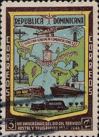
"This monstrosity, on which non-map subjects
are rife...." So the stamp is described by William R. Horney."
Horney's comment is the source for a later description by Walter
Klinefelter. "The all-time low in this catagory [ineptness]
undoubtedly is the distressing effort made to present the partial
world map that is to be found in the design of Dominican Republic A82
[Republic of Dominica 381], a cartographic monstrosity if there ever
was one, for almost all of the detail laid down therein is inexact."
The Carto-Philatelist II:1:10.


 |
