|
Christian Sgrooten (Sgrothenthum, Schrotenus, Schrot) (ca. 1532-1608)
was Geographer Royal to Philip II, of Spain. {Philip also held the Low
Countries as a gift from his father, Charles V.) Sgrooten made surveys
and maps of the Netherlands, and contributed to the atlases of
Ortelius. He also edited two manuscript atlases in 1575 and 1592. Meridianus Partitionis inter Castellanos et
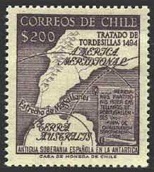
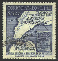
Portugallenses identifies the curved meridian of the Treaty of
Tordesillas. The slogan at the bottom of the stamps, "Antigua
Soberania Española en la Antarctica" asserts Spain's old claim to the
Antarctic.
The Chilean stamps have a design based on a map by
Sgrooten dated 1588 which shows Antarctica, the Straits of Magellan,
and a part of South America. The stamps were issued in 1959 to
commemorate the Treaty of Tordesillas which was agreed to by Spain and
Portugal in 1494.
The Treaty resolved the rival claims of Spain and
Portugal to newly discovered territories. Originally, Spain claimed
all lands west of a line of demarcation 100 leagues west of Cape
Verde, while Portugal received the lands to the east of this line.
John II of Portugal negotiated a treaty with Spain moving the line 270
leagues further west to 46° West. As a result Portugal
succeeded in laying claim to Brazil, its only colony in the new world.
A copy of Sgrooten's map is preserved in the National
Library of Madrid. It was reproduced in Pinochet de la Barrra's book
La Antárctica Chileana,1955.
 
 |
