|
St. Lucia
A cadastral survey
is made to determine the location, ownership, and value of landed
property. The term is loosely used of a survey "sufficiently large to
show the extent and measurement of every field and other plot of land
(Oxford English Dictionary."
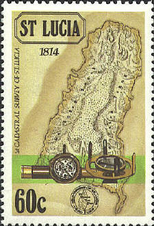
Each of the four stamps issued to commemorate the
first such survey of St. Lucia shows a dated relief map and pictures
of survey instruments of the period. The 15¢ stamp, dated 1775,
features a survey monument, a compass, and a plane table. The 60¢
stamp is dated 1814, with a telescope, watch, and plane table. The $1
stamp, 1888, has a transit, a meansuring device, ruler, and what
appears to be a barometer. The $2.50 stamp, 1987, has a modern
transit, tape measure, and meter stick.


 |
