|
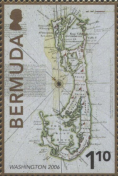
Bermuda
924
To commemorate the World
Philatelic Exhibition in 2006 in Washington, D.C. Bermuda issued a
souvenir sheet featuring “A New and Accurate Map of the Bermudas or
Sommers Islands,” published about 1747 by Emanuel Bowen in the first
volume of his atlas entitled, A complete system of Geography. Being a
description of the countries, islands, cities, chief towns, harbours,
lakes, and rivers, mountains, mines, &c of the known world...In two
volumes. The whole illustrated with seventy maps, by Emanuel Bowen,
Geographer. The map shares a sheet with the island of St. Kitts.
The islands were first named after Juan de Bermúdez who
landed there in 1505. They were renamed Sommers’ Islands for Sir
George Sommers who was forced ashore in 1610 by a hurricane. Sometimes
the name is misspelled “Summers.”
At the west end of the islands is Sandys parish. On
this map as on other maps of the Bermudas the name is misspelled,
Sandy's. The parish was named for Sir Edwin Sandys, and is pronounced
"Sands." See also
Bermuda 148.
There are several notes describing the dangers of the
waters surrounding the island.
Upper Right: Among a great many wrecks of
Vessels on these Rocks, is said to be a very Rich Spanish Ship lost
near a hundred years since, which tho' once discovered, has ever since
been Fished for in vain. ~
Right Side: This is the boldest Coast
about. Bermudas wherein some places the largest ships may come with
safety within half Gunshop of the Shore. ~
Bottom: Of this end of the Island, from
W.W. to N.W. are a great many Rocks at 3 or 4 Leagues distant from the
Land, whereon a great Number of Ships have been lost or have otherwise
received much Damage.
Cartouche: A New & Accurate Map of
Bermudas or Sommer's Islands taken from an Actual Survey; wherein the
Errors of Former Charts are Corrected. By Eman. Bowen
Middle Right: The Bermuda or Sommer’s Islands lye in Lat: 32°„20
North and in Long. 64°„48’ West from London according to an Exact
Astronomical Observation ~ The Channels into the two Harbours are very
narrow & too difficult to be attempted with safety, without a good
Pilot. The Tides seldom rise above 5 feet but y. Current which sets to
the N.E. from the Gulf of Florida is so very strong that Vessels bound
from the Northern &c Southern Plantations in America to Bermudas have
been carried 40 or 50 Leagues to the Eastward of it, tho’ the
Commanders expected when they came into that Latitude, to have found
themselves at as great a distance to the Westn’ard. Daily instances
show that a great many Ships which Trade to and from the West Indies
&c. are by means of the said Current carried so far out of their true
Course as to pass within sight of these Islands. By this means ye
Spanish Flotilla of 13 or 14 Sail coming from the Havana to Old Spain
in 1722, narrowly escaped being shipwrecked on the Western Coast of
these Islands; which side, together with ye Nth side, are full of
dangerous Rocks and that in some places even at the distance of 4 or 5
Leagues of Land.
Upper Left: Hereabout they Fish for
Whales from the latter end of March, 'till the middle of May,
generally with good Success.


 |