|
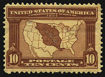
The first postal map stamp issued by the United States
was issued in 1904 to commemorate the centennial of
the Louisiana Purchase. It is based on a U.S. Land Office Map and
shows a map of the United States with the Louisiana Territory shaded.
The northwestern border of the Louisiana
Purchase with Canada was not the 49th parallel as shown on the stamp.
Instead it extended north of that parallel, while Canada intruded into
northern Minnesota and North Dakota. These departures from the 49th
parallel were mutually ceded in the Convention between Great Britain
and the United States in 1818, so that from the Stony Mountains to the
Lake of the Woods, the border follows the 49th parallel. Another error
is the claim of territory in Spanish Florida. The United States
acquired Florida from Spain by the Adams-Onís Treaty of 1819.
 
 |